Supervision of Flood Control Development – West Limboto Area, Gorontalo

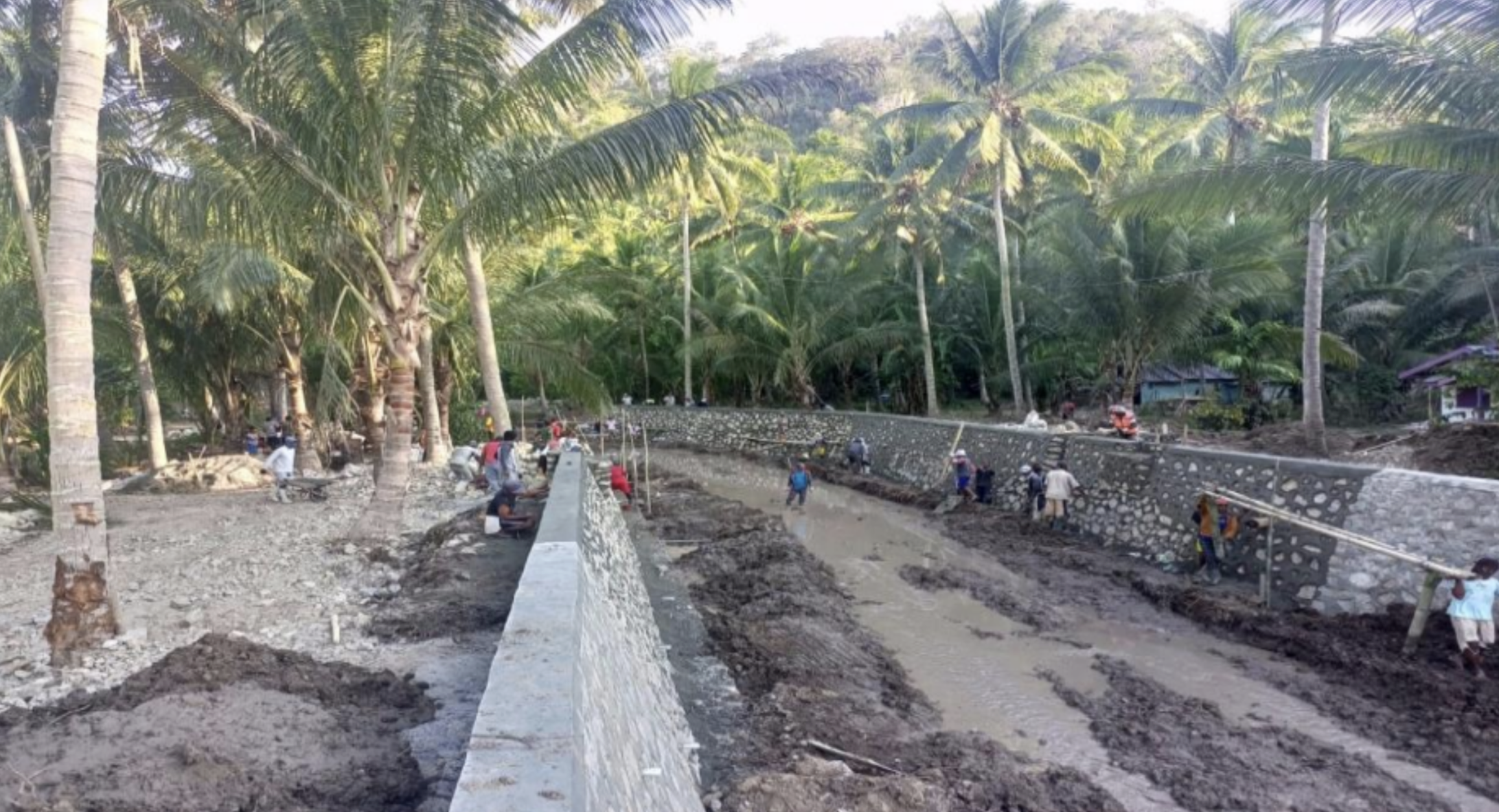
The West Limboto River Basin (91,004 ha), part of the Limboto-Bolango-Bone (LBB) Watershed in Gorontalo, plays a vital role in water resource management for irrigation, raw water, and livelihoods. However, high rainfall in upstream areas, coupled with reduced river capacity, has frequently caused flooding in downstream districts, particularly in densely populated areas of West Limboto.

To address this, the Sulawesi II River Region Office (SNVT Sulawesi II Water Resources) commissioned a Supervision Consultant to oversee the construction of flood control infrastructure. The consultant applied the Assistance Concept, taking full responsibility for supervision activities from design review to project completion.

🔸 Scope of Work

  1. Construction Management: controlling schedules, material quality, construction methods, work volume, and financial absorption.
  2. Engineering Review & Modification: reviewing design analyses, revising calculations, supervising detailed drawings, fabricated materials, installations, and reporting.
  3. Testing & Compliance: reviewing and approving testing procedures during fabrication, delivery, and installation to meet contract specifications.
  4. Field Supervision: ensuring all contractor activities adhered to technical requirements and quality standards.

🔸 Challenges & Solutions

  • Land preparation issues: resolved through coordination with landowners and village government.
  • Excavation spoils blocking farmers’ roads: addressed by relocating materials to mutually agreed areas.
  • Work safety (K3) compliance: supervision reinforced the immediate implementation of PPE and safety standards.

This project strengthened the resilience of the West Limboto area by improving river capacity, reducing flood risk, and protecting surrounding communities and agricultural land, while ensuring construction quality and regulatory compliance.


Flood Control Supervision of Grindulu River and its Tributaries

The Grindulu River, the largest and longest river in Pacitan Regency, flows into the southern coast of Java and has long been prone to flooding and riverbank erosion. To mitigate these risks, flood control infrastructure such as stone parapets and cliff protectors was built in 2009-2010 at critical locations. However, erosion remains a serious issue, especially at outer bends of the river, where it threatens existing embankments, parapets, and densely populated settlements. Recognizing the urgency of further protective measures, the Directorate of Water Resources under the Ministry of Public Works and Public Housing (PUPR) initiated the Flood Control Project for Grindulu River and Its Tributaries in 2023. Managed by the Bengawan Solo River Basin Center through the Specific Non-Vertical Work Unit for the Implementation of the Bengawan Solo Water Source Network, the project was closely monitored by a Supervision Consultant Team to ensure compliance with technical specifications, quality standards, and contractual obligations.

The flood control construction work was successfully completed by October 20, 2023, achieving 100% physical completion, while 95% of financial obligations were met, with the remaining 5% allocated for the maintenance period. During this period, contractors are responsible for maintaining gabion structures, ensuring they remain clean and free from debris such as logs and bamboo clumps that could compromise their integrity. They must also replenish any loss of gabion filling to maintain structural solidity and conduct regular inspections after flood events to identify potential weaknesses and prevent further damage.

By implementing sustainable flood control measures, the Grindulu River Flood Control Project enhances disaster resilience, protects local communities, and safeguards critical infrastructure from future flooding. The integration of technical supervision, structural reinforcements, and proactive maintenance strategies ensures long-term flood mitigation for Pacitan Regency, securing both residential areas and key transportation networks.

Status: 100% Completed – Maintenance Period Ongoing


Flood Supervision for Downstream Konto River, Jombang Regency

To enhance community welfare and flood resilience, the Brantas River Basin Center has been actively managing water resources and flood mitigation efforts across Jombang Regency. The region is traversed by major rivers, including the Brantas River and its tributaries: Konto River, Jarak River, Pakel River, and Gunting River, as well as key reservoirs such as Kepuhrejo, Grogol, Sidowayah, and Brumbung Reservoirs. Among these, the downstream Konto River in Bandar Kedung Mulyo is a critical transportation corridor, hosting the Surabaya-Madiun highway bridge and railway bridge.

The 2021 flood event along the Konto River was one of the worst in the last decade, significantly impacting areas downstream of Selorejo Reservoir, from Ngantang, Malang Regency, to Bandar Kedung Mulyo, Jombang Regency. To address these issues, the 2023 Budget Year allocated funding for flood control infrastructure supervision through the Brantas River Basin Center under the SNVT Implementation of the Brantas Water Source Network. The project was contracted under Unit Price Contract No. PB.03.01-Am.07.3/2023/SPV Konto, awarded to PT. Globetek Glory in collaboration with Atrium Architect Consultant and Karya Gemilang.

The Flood Control Construction Supervision for the Downstream Konto River was conducted over eight months (March 28 – November 24, 2023), focusing on ensuring technical compliance, construction quality, and timely completion. The supervision consultant was responsible for:

✔ Monitoring and controlling construction quality to meet technical standards.

✔ Conducting design revisions to optimize budget use, adjust dimensions, and enhance structural integrity.

✔ Improving safety and functionality for long-term flood protection.

✔ Ensuring smooth project execution by coordinating material stockpiling, site access, and workforce readiness.

✔ Engaging local communities through coordination meetings to facilitate land use, village roads, and material transport.

The project supervision underwent two contract revisions due to necessary adjustments in design specifications, construction methodology, and site conditions. By integrating expert technical personnel, community involvement, and adaptive engineering solutions, this initiative aims to enhance flood resilience, infrastructure sustainability, and environmental safety in Jombang Regency.

Status: 100% Completed – Construction Supervision Successfully Executed


Gongseng Dam Operation Certification and Infrastructure Overview

The Gongseng Dam was constructed to enhance water resource management, support irrigation services, and strengthen food security in Bojonegoro Regency. Additionally, the dam plays a vital role in providing raw water for the surrounding community, while also contributing to flood mitigation and renewable energy potential. With the completion of its physical construction, an Operation & Maintenance (OP) Certification is required to ensure the dam can be fully operational and utilized efficiently.

The Gongseng Dam features a rock-fill structure with a vertical core, designed for long-term stability. It provides essential functions such as supplying irrigation water for 6,191 hectares of farmland, reducing flood risks by 176.44 m³/sec, generating microhydro power with a potential of 0.70 MW, and delivering 300 liters per second of raw water for domestic and industrial needs.

From a geological perspective, the dam is built on marl rock formations, requiring careful structural evaluation to ensure long-term stability and groundwater infiltration control. Given the potential for seismic activity, foundation reinforcement using grouting techniques is necessary to maintain structural integrity and prevent water seepage along fault zones.

Efficient operation of the Gongseng Dam depends on well-maintained hydromechanical equipment, which facilitates water discharge, regulation, and overall system performance. This includes gates, valves, and spillway control mechanisms, all of which require routine inspections and preventive maintenance to ensure optimal functionality. By integrating modern engineering solutions, proactive maintenance strategies, and regulatory compliance, the Gongseng Dam is positioned as a key water infrastructure asset, supporting regional development, water conservation, and disaster mitigation efforts.

📍 Key Specifications:

  • Dam Type: Rock Fill with Vertical Core
  • Main Dam Height: 34.00 m | Saddle Dam Height: 12.00 m
  • Total Peak Length: 422.00 m
  • Reservoir Capacity: 22.43 million m³ (Effective: 14.75 million m³, Dead Storage: 7.68 million m³)
  • Inundation Area: 390.65 Ha | Water Catchment Area: 51.21 km²

Status: 100% Completed – OP Certification in Progress


Design Review for Soamaetek and Leleoto Irrigation Systems

The agricultural sector remains a top priority for national development, with stable food security being a key objective of the current government program. However, challenges such as land conversion for plantations, increased rice demand, and the influx of imported rice pose significant threats to domestic agricultural sustainability. Based on the North Halmahera WS PSDA Pattern (2020), several potential irrigation areas have been identified for development, yet they are not included in Ministerial Regulation No. 14 of 2015. To support the expansion of irrigation infrastructure, the 2023 Budget Year has allocated resources for the Planning Review of DI. Soamaetek (223 Ha), DI. Kusuri (178 Ha), and DI. Paca-Leleoto (159 Ha). These areas, located in North Halmahera Regency, possess excellent soil conditions, favorable topography, and abundant water resources, making them highly suitable for irrigation enhancement.

In the supplementary irrigation channel, an existing water gate is used to regulate water flow for rice fields in Leleoto Village. However, local farmers have reported that during heavy rainfall, the channel cannot accommodate excess water, causing overflow into the rice fields. Additionally, the small size of the water gate restricts water flow, leading to inefficiencies in irrigation and flood mitigation. Farmers have requested the removal and enlargement of the water gate to ensure smoother water distribution. Since the asset belongs to the Agriculture Service of North Halmahera Regency, any modifications require official coordination. As a solution, it is recommended that the existing water gate be replaced with a larger structure, designed to improve water regulation, prevent flooding, and enhance agricultural productivity.

Status: Ongoing – Planning & Coordination Phase


Actual Needs for Operations and Maintenance (AKNOP) for Citarum River Flood Management

Performance evaluation is a continuous process conducted by the Operation & Maintenance (OP) Implementing Unitto assess the effectiveness, efficiency, and quality of river infrastructure management. This evaluation ensures accountability in budget utilization, improves service effectiveness, and measures community satisfaction. Conducted at the end of the inventory survey period, the evaluation involves verifying data and comparing it with standardized performance benchmarks. The assessment process determines whether the river infrastructure requires preventive, corrective, or rehabilitative maintenance, ensuring optimal operation and long-term sustainability.

The evaluation serves multiple functions, including ensuring the proper use of OP funds, allowing the Supervisory Directorate to monitor fund allocation, enhancing performance within the OP unit, and measuring public satisfaction with OP services. Performance assessment relies on four key factors: organizational capacity, which examines available resources; organizational productivity, which evaluates service efficiency and effectiveness; service quality, which reflects community satisfaction levels; and responsiveness, which assesses how well OP units accommodate public concerns and adapt to changing environmental conditions.

The performance evaluation process is carried out using a structured periodic reporting system that provides insights into strategic achievements, performance gaps, and improvement areas. By integrating input, process, output, and outcome indicators, this initiative ensures that OP activities align with national water resource management policieswhile maintaining high operational standards. Ultimately, this evaluation framework strengthens sustainable infrastructure management and disaster resilience, supporting reliable flood control and water distribution services.

Status: Ongoing – Continuous Performance Monitoring & Optimization


id_IDIndonesian