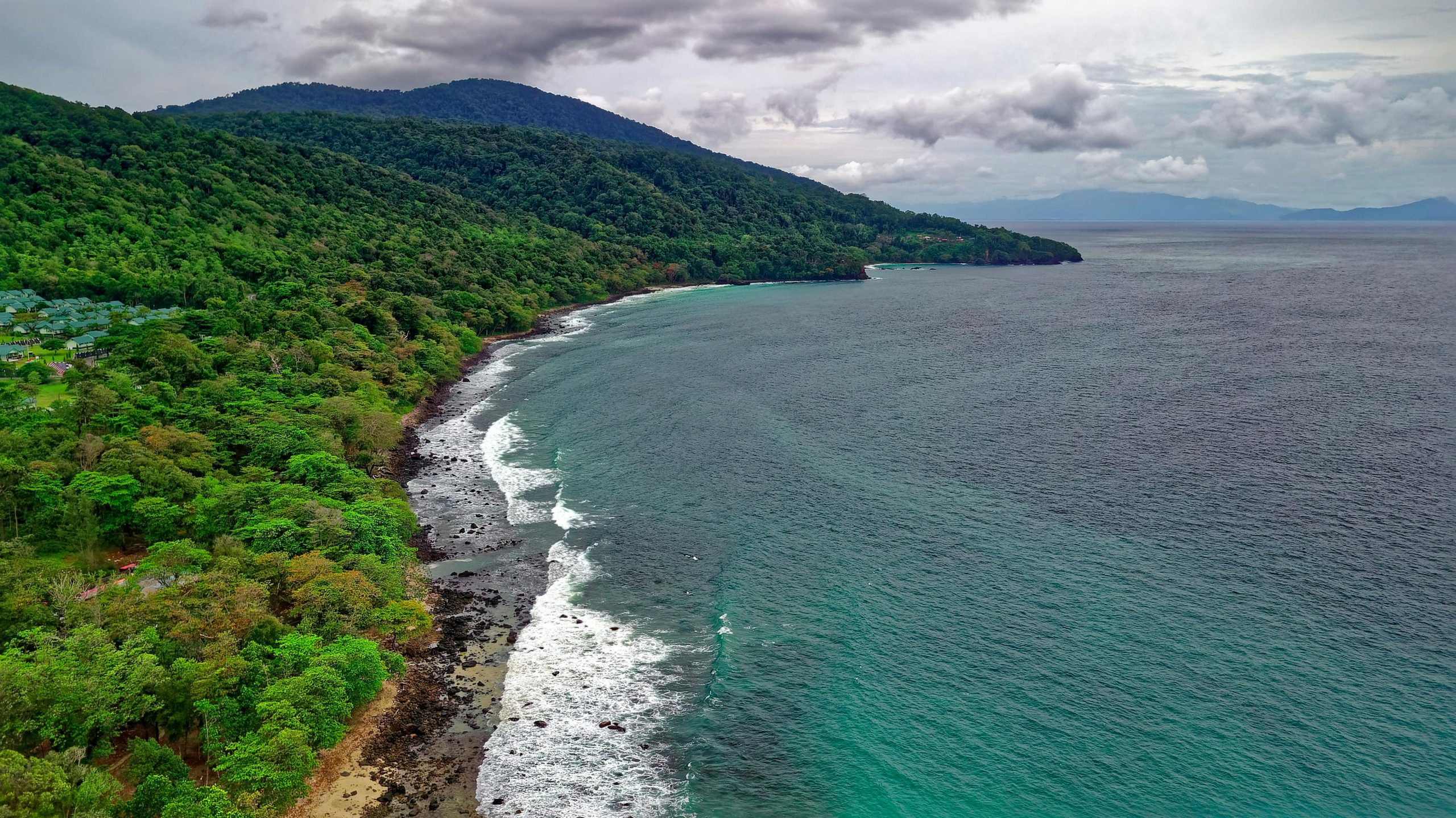
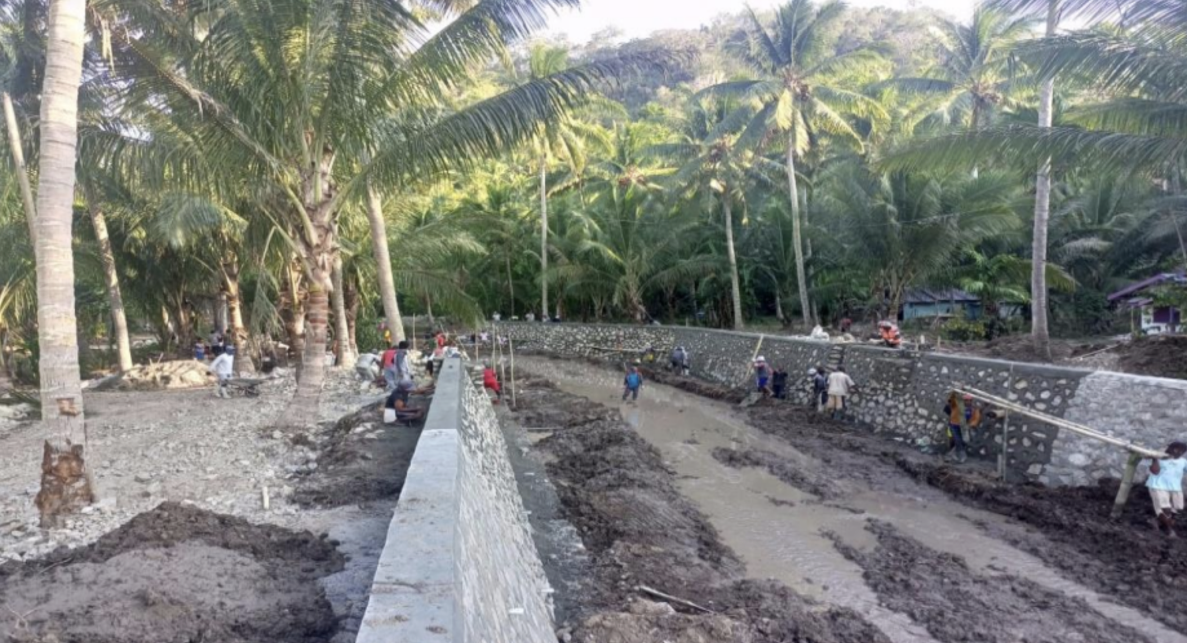
Kuala Kampar Beach Security Survey, Investigation, and Design (SID)

Coastal erosion caused by strong wave impacts has led to land loss and poses a threat to public facilities. Therefore, a project was initiated to develop a detailed construction plan for coastal protection, serving as a guideline to safeguard the area from further erosion. Located in Kuala Kampar District, Pelalawan Regency, Riau, this coastal region is experiencing severe erosion in several critical areas, characterized by unique hydrodynamic conditions due to the Bono phenomenon (strong tidal currents).

Several surveys were conducted to support project planning, including topographic, bathymetric, soil mechanics, hydrology, and socio-economic surveys. These aimed to assess coastal conditions, tidal dynamics, and the project’s impact on the local community. Based on the findings, key coastal protection measures were proposed, such as breakwaters to dissipate wave energy, revetments for direct shoreline protection, jetties to manage sedimentation, and groins to reduce sand movement and prevent erosion. The project is expected to mitigate coastal erosion, enhance community safety, and create job opportunities while addressing challenges like sedimentation, ecosystem shifts, and workforce development for local labor involvement.


Flood Alert Level Review for Cirarab River

The Flood Alert Level Review for Cirarab River was conducted to assess the causes of severe flooding in Tangerang and to formulate effective mitigation strategies. The study identified key issues, including obstructed river flow due to bridge structures, inadequate embankment elevation in Gelam Jaya Village, and sedimentation and narrowing near Akong Factory in Sepatan District. These factors significantly contributed to prolonged flooding, necessitating urgent river normalization and infrastructure improvements. The study also revealed that six out of sixteen drainage gatesalong the Cirarab River embankment were non-functional, limiting the flood drainage capacity, especially in Villa Permata Tangerang. Additionally, the Sarakan Dam, located on the border of Gitung Village and Kosambi Village, remained structurally intact but had three damaged floodgates that were temporarily replaced with wooden partitions.

The evaluation covered existing water resource infrastructure, including water level monitoring posts, water pumps, drainage gates, and embankments. It was found that only one out of three water monitoring posts was integrated with an online early warning system managed by Tangerang BPBD, while the others functioned as manual Water Guessing Posts (PDA) at the Ledug River Estuary and Situ Bulakan Estuary. The study also recorded nine operational water pumps, strategically placed for lake discharge, drainage, and river estuaries. Most embankments along Gelam Jaya Village in Pasar Kemis District were in good condition, but some sections showed visible cracks requiring maintenance.

To enhance flood preparedness, flood discharge calculations were performed using three different methods: the HSS method, HEC-HMS software modeling, and AWLR data analysis. The insights gained from this study provide a comprehensive foundation for flood risk reduction, infrastructure improvement, and sustainable urban resilience planning in the Cirarab River basin. By implementing these recommendations, the local government can ensure a more effective flood response system, reducing future flood impacts on residential and industrial areas in Tangerang.

Status: 100% Completed – Ready for Implementation


Performance Evaluation and AKNOP (Actual Needs for Operations and Maintenance) Development for Rivers in Manado City, Minahasa Regency, and North Minahasa Regency

As part of a commitment to sustainable water resource management, this project aims to assess the operational performance of river infrastructure and develop the Actual Needs for Operations and Maintenance (AKNOP) to enhance the efficiency and effectiveness of river management. Covering the City of Manado, Minahasa Regency, and North Minahasa Regency, this project focuses on 15 key rivers that play a crucial role in the regional hydrological system and flood mitigation efforts.

The implementation involves a data-driven and technically comprehensive approach, including infrastructure inventory, institutional assessment, hydrological and topographical surveys, and physical condition mapping of river facilities. Leveraging modern technology and strict technical standards, each stage of the assessment is conducted systematically to generate strategic recommendations that can be effectively implemented.

This project adheres to the latest regulations, including UU No. 17 of 2019 on Water Resources, as well as technical guidelines from the Ministry of Public Works and Housing (PUPR) of Indonesia regarding river operations and maintenance. The key deliverables include a River Operations and Maintenance Performance Assessment Report, Operations & Maintenance Manual, Cost Budget Plan (RAB), as well as visual documentation and thematic maps, serving as primary references for optimizing river infrastructure management.

A multidisciplinary approach and synergy with various stakeholders are the keys to ensuring that the proposed recommendations effectively address future challenges in river management. With a fact-based analysis and measurable methodologies, this project is expected to make a tangible impact on enhancing the efficiency of river operations and maintenance across Indonesia.


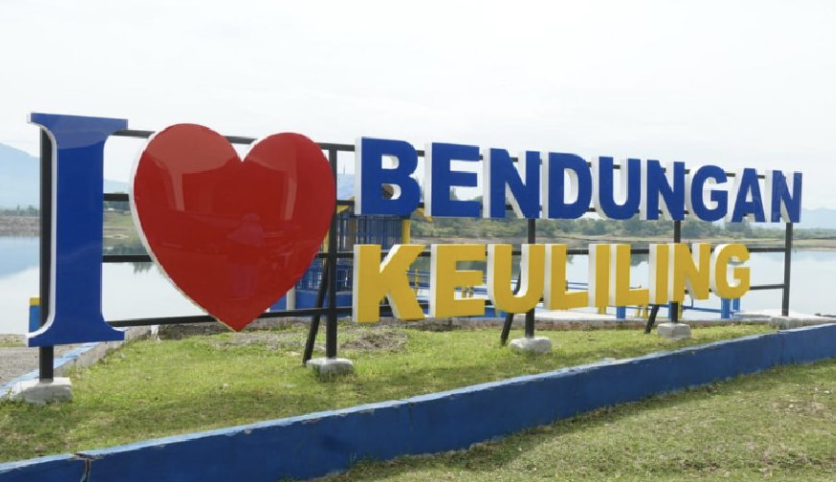
Supervision of Keuliling Reservoir Rehabilitation – Cot Glie District, Aceh Besar, Aceh

The Keuliling Reservoir, part of the Krueng Aceh Watershed, plays a critical role in providing raw water and irrigation for Banda Aceh and Aceh Besar. Constructed to irrigate over 3,700 hectares of agricultural land, the reservoir also supports the conversion of rain-fed fields into technically irrigated rice fields. Beyond water supply and irrigation, Keuliling Reservoir has the potential to serve as a hub for sports, tourism, and community activities.

Located in Cot Glie District, Aceh Besar Regency, approximately 35 km from Banda Aceh, the reservoir rehabilitation supervision project ensures construction quality and compliance with technical standards while integrating landscape planning for environmental sustainability, tourism, and sports development.

🔸 Landscape Development Highlights

  1. Utilization of dredged material areas around the reservoir pool for greening, tourism, and sports facilities, aligned with the preparation for PON XXI (2024).
  2. Disposal Areas 1 & 2:
    • Alternative 1: Tourism-focused design, including interactive playgrounds, shallow-water tourism, sports facilities, and supporting amenities (toilets, prayer rooms, food stalls).
    • Alternative 2: Agrotourism design with fruit tree zones, complemented by basic facilities (prayer rooms, toilets).
  3. UPB Office & Housing Complex: Landscaping, garden improvements, and addition of a guesthouse (5 rooms) for staff and visitors.
  4. Mushalla Area Renovation: Facade enhancement inspired by the Baiturrahman Grand Mosque and improved landscaping.
  5. Disposal Areas 3, 4 & 5: Dedicated for greening and agrotourism, accessible only by boat.

This project demonstrates an integrated approach to water resources rehabilitation and multifunctional landscape planning, combining irrigation, environmental sustainability, tourism, and community facilities to maximize the long-term benefits of Keuliling Reservoir.


Supervision of Coastal Protection Construction – Ibu District Phase II, West Halmahera, North Maluku

The Ministry of Public Works and Public Housing (PUPR) of the Republic of Indonesia, through the Directorate of Water Resources, is responsible for developing water resources infrastructure to safeguard communities and support sustainable coastal management. In the 2023 Fiscal Year, the Directorate commissioned the Supervision of Phase II Coastal Protection Construction in Ibu District, West Halmahera Regency, North Maluku Province.

🔸 Implementation of Supervision

During the supervision process, several important aspects were identified to ensure the effectiveness and sustainability of the project:

  1. Periodic dredging is required at the construction site to address sedimentation caused by waves and tidal movements.
  2. The utilization and management of the coastal protection facilities are to be handed over to the local village government for ongoing operation.

🔸 Construction Implementation

Key factors affecting the success of construction included:

  1. Contractor readiness, particularly in mobilizing equipment, manpower, and qualified technical personnel experienced in coastal protection projects.
  2. Community coordination, especially regarding the use of village facilities (such as access roads) and informing local residents about the project plan.
  3. Pre-construction socialization, which proved essential given the project’s significant impact on local communities and their environment.

🔸 Recommendations

From the findings and supervision activities, several recommendations were made:

  1. For projects with high technical complexity, tender participants should be encouraged to submit detailed construction methods during the bidding stage.
  2. Contractors should ensure the deployment of competent human resources, especially on-site personnel, to guarantee smooth implementation.
  3. Considering the vital role of this project in protecting coastal areas, it is recommended that coastal protection efforts be sustained and integrated with relevant agencies and institutions to maximize long-term benefits.


Supervision of Mud Retaining Embankment Strengthening, Sidoarjo Regency, East Java

The Sidoarjo Mudflow disaster, which began on May 29, 2006, remains an ongoing environmental challenge with no signs of stopping. Located in Siring Village, Porong District, Sidoarjo Regency, East Java, the mudflow has caused severe subsurface instability, requiring continuous mitigation efforts. Under Presidential Regulation No. 21/2017, the responsibility for mudflow management was transferred to the Ministry of Public Works and Housing (PUPR), which established the Sidoarjo Mudflow Control Center to oversee operations.

Due to weak soil bearing capacity, frequent embankment slides, and seepage at several points, reinforcement of the mud retaining embankment became essential. In 2023, the government initiated the Supervision of Embankment Strengthening project, with the Supervision Consultant tasked to ensure safe, effective, and sustainable embankment improvement.

🔸 Scope of Work

  • Continuous supervision of mud retaining embankment strengthening works, ensuring compliance with technical standards.
  • Monitoring structural stability, addressing landslide risks, and preventing seepage through advanced inspection and instrumentation.
  • Conducting routine, periodic, and annual inspections to evaluate functional and structural integrity.
  • Implementing maintenance and repair strategies to extend the embankment’s service life.
  • Coordinating with stakeholders to support social, economic, and cultural activities affected by the mudflow.

🔸 Key Benefits

  • Enhanced safety → improved structural integrity of the embankment, reducing flood and collapse risks.
  • Sustainability → regular inspections and preventive maintenance to maintain service function.
  • Community protection → securing surrounding settlements, infrastructure, and socio-economic activities.
  • Disaster resilience → strengthening long-term mitigation capacity against the continuing mudflow phenomenon.

This project demonstrates Indonesia’s commitment to long-term disaster management, ensuring that the Sidoarjo Mud Retaining Embankment continues to safeguard both the environment and the community.


Supervision of Waemese River Flood Control

The Waemese River, located in West Manggarai Regency, Flores Island, is a critical waterway within the Flores River Basin, designated as a National Strategic River Area. However, during the rainy season, the river frequently experiences severe flooding, inundating residential areas, agricultural land, and public infrastructure such as highways, offices, and irrigation systems. The persistent riverbank erosion is driven by multiple factors, including rainfall intensity, watershed slope, river morphology, and land use changes. Additionally, soil characteristics and runoff coefficients play a crucial role in determining sediment transport and overall flood impact.

To mitigate the effects of riverbank erosion and destructive water forces, and in response to community requests submitted through the West Manggarai Regency Government, the Directorate General of Water Resources, Ministry of Public Works and Public Housing (PUPR), through the Nusa Tenggara II River Basin Center, has initiated the Continued Development of Flood Control Infrastructure for the Waemese River in Labuan Bajo, West Manggarai Regency. This initiative requires close supervision by a qualified consultant to ensure that the construction adheres to technical standards, sustainability principles, and coordinated project management.

The project mandates the involvement of certified contractors and consultants, with the required qualifications being Intermediate-level Business Entity Certification and expertise in Civil Engineering Construction Work Supervision (RE203 Sub-Classification). The implementation of this project demands efficient operational management, phased execution, and strict quality control, ensuring that all flood control measures are effective, sustainable, and aligned with national water resource management goals.

Status: 100% Completed – Flood Control Infrastructure Fully Operational


Supervision of Flood Control Development – West Limboto Area, Gorontalo

The West Limboto River Basin (91,004 ha), part of the Limboto-Bolango-Bone (LBB) Watershed in Gorontalo, plays a vital role in water resource management for irrigation, raw water, and livelihoods. However, high rainfall in upstream areas, coupled with reduced river capacity, has frequently caused flooding in downstream districts, particularly in densely populated areas of West Limboto.

To address this, the Sulawesi II River Region Office (SNVT Sulawesi II Water Resources) commissioned a Supervision Consultant to oversee the construction of flood control infrastructure. The consultant applied the Assistance Concept, taking full responsibility for supervision activities from design review to project completion.

🔸 Scope of Work

  1. Construction Management: controlling schedules, material quality, construction methods, work volume, and financial absorption.
  2. Engineering Review & Modification: reviewing design analyses, revising calculations, supervising detailed drawings, fabricated materials, installations, and reporting.
  3. Testing & Compliance: reviewing and approving testing procedures during fabrication, delivery, and installation to meet contract specifications.
  4. Field Supervision: ensuring all contractor activities adhered to technical requirements and quality standards.

🔸 Challenges & Solutions

  • Land preparation issues: resolved through coordination with landowners and village government.
  • Excavation spoils blocking farmers’ roads: addressed by relocating materials to mutually agreed areas.
  • Work safety (K3) compliance: supervision reinforced the immediate implementation of PPE and safety standards.

This project strengthened the resilience of the West Limboto area by improving river capacity, reducing flood risk, and protecting surrounding communities and agricultural land, while ensuring construction quality and regulatory compliance.


Flood Control Supervision of Grindulu River and its Tributaries

The Grindulu River, the largest and longest river in Pacitan Regency, flows into the southern coast of Java and has long been prone to flooding and riverbank erosion. To mitigate these risks, flood control infrastructure such as stone parapets and cliff protectors was built in 2009-2010 at critical locations. However, erosion remains a serious issue, especially at outer bends of the river, where it threatens existing embankments, parapets, and densely populated settlements. Recognizing the urgency of further protective measures, the Directorate of Water Resources under the Ministry of Public Works and Public Housing (PUPR) initiated the Flood Control Project for Grindulu River and Its Tributaries in 2023. Managed by the Bengawan Solo River Basin Center through the Specific Non-Vertical Work Unit for the Implementation of the Bengawan Solo Water Source Network, the project was closely monitored by a Supervision Consultant Team to ensure compliance with technical specifications, quality standards, and contractual obligations.

The flood control construction work was successfully completed by October 20, 2023, achieving 100% physical completion, while 95% of financial obligations were met, with the remaining 5% allocated for the maintenance period. During this period, contractors are responsible for maintaining gabion structures, ensuring they remain clean and free from debris such as logs and bamboo clumps that could compromise their integrity. They must also replenish any loss of gabion filling to maintain structural solidity and conduct regular inspections after flood events to identify potential weaknesses and prevent further damage.

By implementing sustainable flood control measures, the Grindulu River Flood Control Project enhances disaster resilience, protects local communities, and safeguards critical infrastructure from future flooding. The integration of technical supervision, structural reinforcements, and proactive maintenance strategies ensures long-term flood mitigation for Pacitan Regency, securing both residential areas and key transportation networks.

Status: 100% Completed – Maintenance Period Ongoing


Flood Supervision for Downstream Konto River, Jombang Regency

To enhance community welfare and flood resilience, the Brantas River Basin Center has been actively managing water resources and flood mitigation efforts across Jombang Regency. The region is traversed by major rivers, including the Brantas River and its tributaries: Konto River, Jarak River, Pakel River, and Gunting River, as well as key reservoirs such as Kepuhrejo, Grogol, Sidowayah, and Brumbung Reservoirs. Among these, the downstream Konto River in Bandar Kedung Mulyo is a critical transportation corridor, hosting the Surabaya-Madiun highway bridge and railway bridge.

The 2021 flood event along the Konto River was one of the worst in the last decade, significantly impacting areas downstream of Selorejo Reservoir, from Ngantang, Malang Regency, to Bandar Kedung Mulyo, Jombang Regency. To address these issues, the 2023 Budget Year allocated funding for flood control infrastructure supervision through the Brantas River Basin Center under the SNVT Implementation of the Brantas Water Source Network. The project was contracted under Unit Price Contract No. PB.03.01-Am.07.3/2023/SPV Konto, awarded to PT. Globetek Glory in collaboration with Atrium Architect Consultant and Karya Gemilang.

The Flood Control Construction Supervision for the Downstream Konto River was conducted over eight months (March 28 – November 24, 2023), focusing on ensuring technical compliance, construction quality, and timely completion. The supervision consultant was responsible for:

✔ Monitoring and controlling construction quality to meet technical standards.

✔ Conducting design revisions to optimize budget use, adjust dimensions, and enhance structural integrity.

✔ Improving safety and functionality for long-term flood protection.

✔ Ensuring smooth project execution by coordinating material stockpiling, site access, and workforce readiness.

✔ Engaging local communities through coordination meetings to facilitate land use, village roads, and material transport.

The project supervision underwent two contract revisions due to necessary adjustments in design specifications, construction methodology, and site conditions. By integrating expert technical personnel, community involvement, and adaptive engineering solutions, this initiative aims to enhance flood resilience, infrastructure sustainability, and environmental safety in Jombang Regency.

Status: 100% Completed – Construction Supervision Successfully Executed


id_IDIndonesian